What Is DLAN?

DLAN simplifies how emergency managers communicate, track resources, and make informed decisions in real time.

Designed around your workflows, DLAN adapts to any mission—ensuring all stakeholders see the same information, at the same time.

Key Highlights

  • Unified operations connecting field, command, and support
  • Configurable to your agency’s structure
  • Proven reliability across real-world deployments
“DLAN transformed our coordination process. We operate faster, with clearer communication, and complete visibility.” Emergency Operations Director, Midwestern County OEM

DLAN Capabilities

DLAN’s modules work together to provide a complete picture of your operations — from the first alert to the final report.

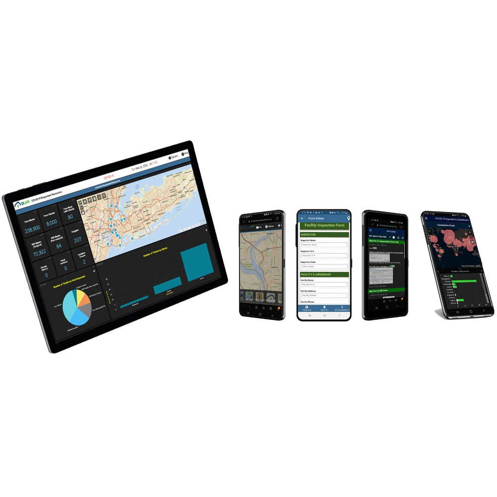
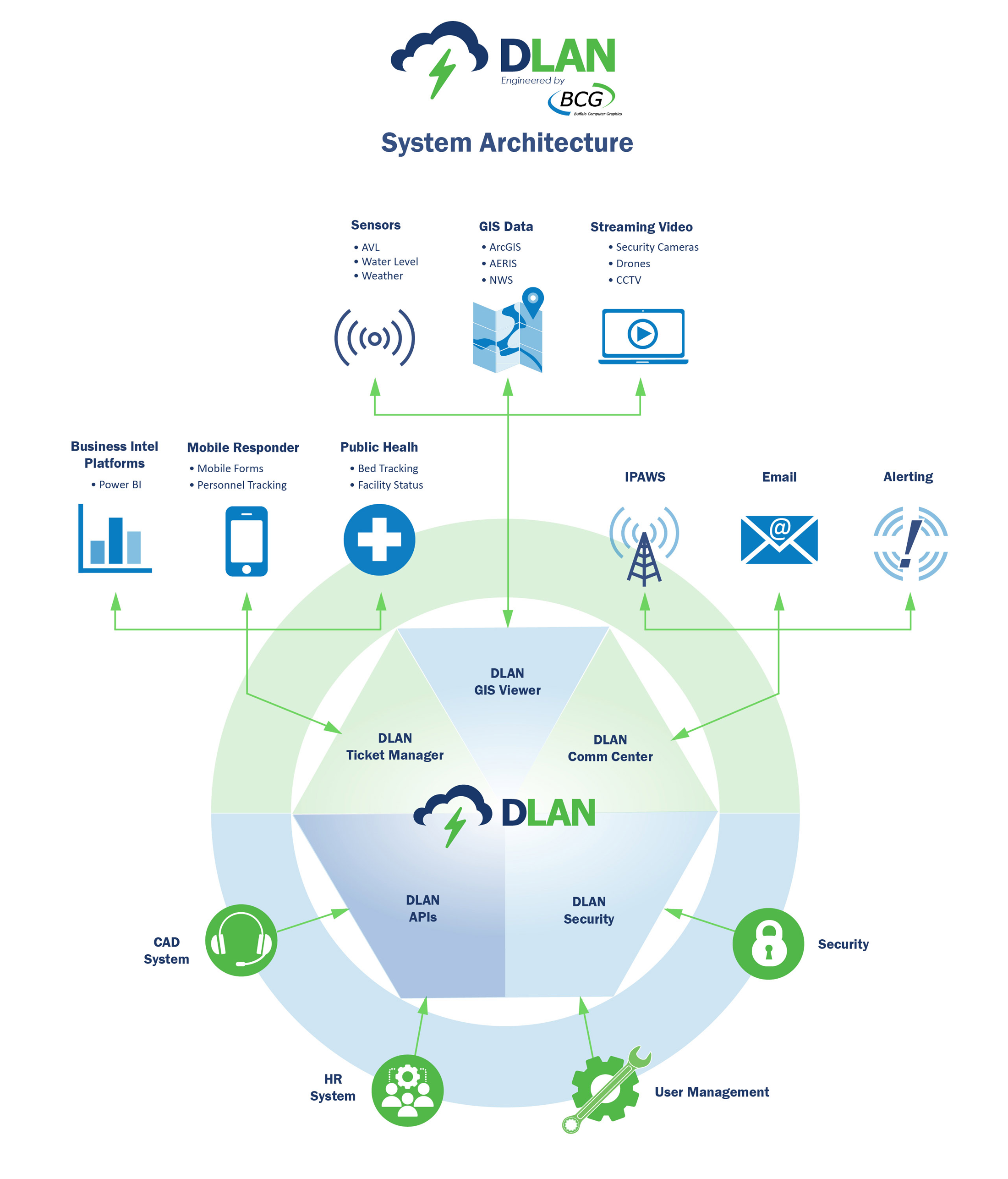
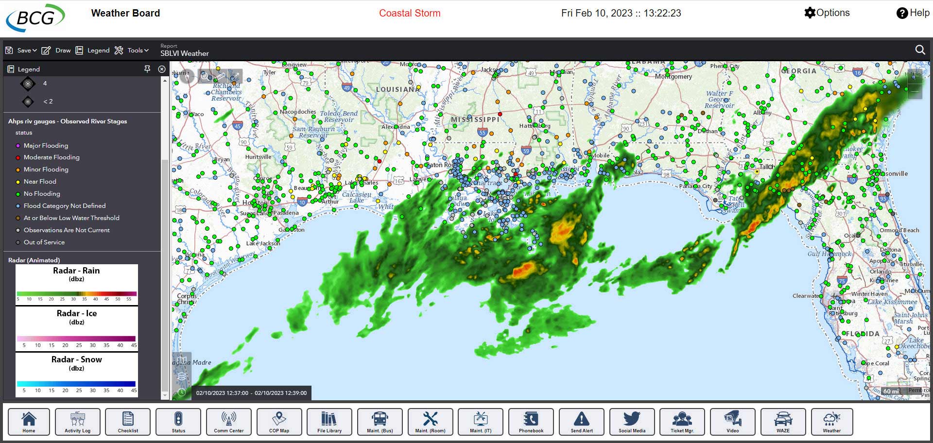
Common Operating Picture / GIS Mapping

Visualize data, weather, and assets in real time with integrated GIS mapping and live dashboards. Monitor multiple locations, overlay external data sources, and turn raw information into actionable insight.

Key Features:
  • Real-time situational awareness with map layers and live feeds
  • Configurable dashboards for multiple incident views
  • Integration with ESRI, weather, and sensor data
  • Simplified visual collaboration across agencies

In Practice: The Rochester (MN) Emergency Management team used DLAN to turn static flood-plain data into dynamic map layers during a major rain event — improving decision-making and EOC coordination.

Source – Buffalo Computer Graphics

Resource Management / Asset Tracking

Track personnel, vehicles, and equipment across multiple incidents with customizable workflows and real-time visibility.

Key Features:
  • Customizable forms for personnel, asset, and supply tracking
  • Automated logs and inventory reporting
  • Location and status monitoring through integrated dashboards
  • Multi-site resource allocation and prioritization tools

In Practice: Broome County Office of Emergency Services (NY) used DLAN’s toolset for point-of-distribution and supply tracking during COVID-19, building custom dashboards to manage logistics and resource requests.

Source – GovLaunch

Situation Reporting & ICS Forms

Generate standardized Incident Action Plans (IAPs) and Situation Reports instantly, with full version history, role-based approvals, and real-time collaboration.

Key Features:
  • Pre-built, ICS-compliant templates
  • Workflow-driven approvals and digital signatures
  • Automatic version tracking and audit logs
  • Rapid report generation across departments

In Practice: New York Power Authority (NYPA) maintains a constant state of vigilance for severe weather. DLAN dashboards provide real-time aggregated geospatial data for predictive weather analysis and asset allocation.

Source – Buffalo Computer Graphics

Mobile & Offline Access

Capture data in the field — even without connectivity. Sync automatically once reconnected to ensure your information is never lost.

Key Features:
  • Mobile access to forms and dashboards
  • Offline data capture with automatic sync
  • GPS-tagged photo and video uploads
  • Secure, role-based mobile authentication

In Practice: Westchester County and other NY counties used DLAN during the Indian Point nuclear exercise to upload plume models, overlay critical facilities, and coordinate multi-agency response.

Source – Buffalo Computer Graphics

Notifications & Alerts

Deliver targeted messages across channels — email, text, and radio — ensuring every stakeholder receives critical updates quickly and accurately.

Key Features:
  • Automated alerts and notification templates
  • Multi-channel distribution (SMS, email, radio, in-app)
  • Integrated contact groups and permission controls
  • Two-way communication for confirmation tracking

In Practice: Ventura County OES used DLAN to push shelter and road-closure updates to public maps during the 2018 Woolsey Fire — eliminating duplicate data entry.

Source – Featured Customers

Analytics & Reporting

Turn operational data into insight with automated analytics, visual dashboards, and after-action reporting.

Key Features:
  • Customizable dashboard widgets and metrics
  • Exportable PDF and Excel reports
  • After-action summaries and audit trails
  • Cross-agency performance analysis

In Practice: Across New York State, counties use DLAN as a unified, multi-jurisdictional system — enabling scalable reporting and shared situational awareness from daily operations to statewide emergencies.

Source – Buffalo Computer Graphics

Seamless Integration

Every module connects through DLAN’s central hub, ensuring all data and users operate from a single source of truth. Add new functionality anytime — DLAN scales as your mission evolves.

Ready to See DLAN in Action?

Explore how these modules can adapt to your organization’s mission and strengthen your incident-management capabilities.

Request a Personalized Demo